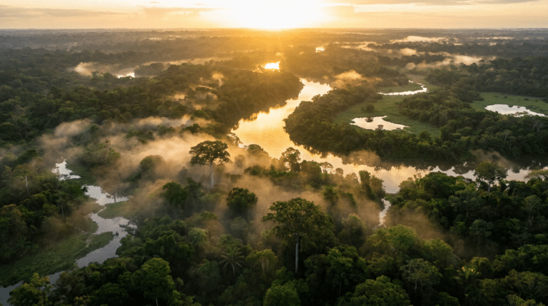
A river can look permanent from a bridge. The water keeps moving, the banks appear fixed, and a map may show the channel as a solid line.
But a river is not a permanent object. It is a moving system that continually transports water and sediment. Given enough time, the channel itself can migrate, split, narrow, widen or abandon its old course.
A river is always reshaping its own path
Moving water exerts force on the bed and banks. Where flow is energetic, sediment can be picked up and transported. Where the current slows, sediment can settle.
This creates a feedback loop. Erosion changes the shape of the channel, the changed shape alters the flow, and the altered flow changes where erosion and deposition occur next.
A river is therefore not simply flowing through a landscape. It is continuously modifying the landscape through which it flows.
Why rivers bend
Meandering rivers are especially good at demonstrating the process.
As water moves around a bend, the fastest flow tends to be concentrated toward the outer bank. That increases erosion there. On the inner side of the bend, slower water encourages sediment deposition.
The bend can therefore become more pronounced over time.
Eventually, two bends may approach each other closely enough for the river to cut through the narrow neck between them. The old loop can become an isolated oxbow lake.
Floods can redraw the map
Large floods carry enormous amounts of water and sediment. A river that normally occupies a stable channel can temporarily spread across its floodplain.
During extreme events, the flow may carve a new channel or enlarge an existing secondary channel. Once the flood subsides, some of that new pathway may remain.
This is one reason floodplains can be both fertile and dangerous. They are productive landscapes precisely because rivers repeatedly deposit sediment there.
Why humans often make rivers less free to move
People build levees, embankments, dams, canals and revetments to protect settlements, farmland, roads and infrastructure.
These structures can reduce local flooding or stabilize a desired channel, but they also change the river’s natural movement of water and sediment.
A channel constrained in one place may transport more sediment elsewhere. A dam can trap sediment that would otherwise travel downstream. A straightened channel can alter flow speed and habitat.
River engineering therefore solves some problems while creating new ones that may appear farther downstream or decades later.
Rivers can move without a dramatic flood
Channel migration does not always require a disaster.
Small changes in bank erosion and sediment deposition accumulate over years. Repeated seasonal flows can gradually shift a bend. Satellite imagery makes it possible to watch some rivers migrate over surprisingly short periods.
In geological terms, these changes can become enormous. An old river channel may eventually lie far from the active river, preserved in soil, sediment or vegetation patterns.
Why ancient rivers matter to archaeologists
A settlement that appears to be inexplicably far from a river may once have stood beside one.
Ancient cities depended heavily on waterways for drinking water, agriculture, transport and trade. If a river migrated, silted up or changed course, the economic geography of a settlement could change with it.
Archaeologists therefore sometimes reconstruct former channels to understand why people settled where they did and why a once-important site later declined.
Rivers remember climate
River deposits also contain environmental information.
Layers of sediment can reveal changes in flood frequency, vegetation, erosion and water availability. Scientists can combine these records with lake sediments, tree rings, ice cores and other evidence to reconstruct past climates.
A river is therefore both an active landscape process and an archive.
There is no single “normal” river
One of the biggest mistakes is to imagine that a river has one correct shape.
River behavior depends on slope, discharge, sediment size, vegetation, geology and human intervention. A braided river can naturally contain multiple channels. A meandering river may migrate across a floodplain. A steep mountain stream can behave completely differently.
What looks like instability may actually be the river operating normally.
The deeper question
Maps encourage us to think of rivers as lines.
Nature treats them more like moving zones.
The channel we see today is only the latest position in a much longer history of erosion, deposition, floods and changing climate. If we could watch a river for thousands of years, the apparently permanent line on a map would become a constantly moving trace.
The river does not merely travel through the landscape.
It helps create the landscape itself.
Why a river often erodes one bank and builds the other
Flow through a bend is not evenly distributed. The outer bank experiences stronger erosive forces, while slower water near the inner bank allows sand and gravel to settle. This asymmetry can make a bend grow progressively larger.
Vegetation complicates the process. Roots can stabilize banks, while the removal of vegetation can make erosion easier. The result is a constant negotiation between water, sediment and the living landscape.
What is a cutoff?
When a meander becomes sufficiently tight, a flood may allow water to cross the narrow neck of land between two parts of the bend. The river then follows the shorter route, leaving the old loop disconnected.
The abandoned loop can become an oxbow lake. Its shape is therefore a snapshot of an earlier river position.
Why rivers sometimes split into many channels
Not all rivers meander. Braided rivers divide into multiple shifting channels separated by sediment bars. They tend to form where sediment supply is high and banks are less able to hold a single stable channel.
Looking at a braided river as a “messy” version of a normal river misses the point. Multiple channels can be the natural expression of the river’s sediment and flow conditions.
Floodplains are built by repeated movement
A floodplain is not simply land next to a river. It is a landscape partly created by the river’s repeated overflow and sediment deposition.
Fine sediments can make floodplains agriculturally productive, which explains why humans repeatedly settle them despite flood risk.
The same process that creates fertile land also creates the hazard.
Dams change more than water levels
Dams can reduce flood peaks, store water and generate electricity, but they also trap sediment that would otherwise move downstream. This can affect riverbanks, deltas, wetlands and coastal environments.
Engineers therefore have to manage not only the quantity of water but also the movement of sediment through the system.
Climate can move the river’s equilibrium
Changes in rainfall can alter discharge and flood frequency. Changes in vegetation can alter erosion. Wildfires can increase sediment runoff. Human land use can change how quickly rain reaches a channel.
A river’s shape is therefore a record of many interacting processes rather than a response to water alone.
Why a changing river is not necessarily a failing river
People often interpret channel migration as evidence that a river is “unstable.” In many natural systems, movement is the normal state.
The real question is whether the rate and location of change are compatible with the surrounding ecosystem and human infrastructure. A river can be healthy while moving, and dangerous while appearing stable.
Erosion and deposition work together
A river changes course because sediment is continually being removed from some places and deposited in others. When flow becomes faster or more turbulent, it can erode a bank. Where velocity falls, sediment may settle.
Over long periods, these small changes can move an entire channel across its floodplain.
Why meanders migrate
In a bend, water tends to move faster along the outer bank and slower along the inner bank. The outer bank therefore experiences stronger erosion, while sediment is more likely to accumulate on the inner side.
This creates a feedback loop: the bend becomes more pronounced, which can increase the difference in flow between its two sides.
Cutoffs can suddenly redraw a river
When a meander loop becomes sufficiently narrow, floodwater may eventually create a shorter route across the neck of the bend. The river can abandon the old loop, leaving an oxbow lake or an isolated channel.
What looks like a sudden change is often the final stage of a much longer period of gradual migration.
Floods accelerate change
Large floods can move enormous quantities of sediment and reshape banks in hours or days. Because extreme floods are relatively infrequent, a river’s appearance can change dramatically between two observations even though the underlying processes have operated continuously.
Human engineering can interrupt the cycle
Dams, levees, bank protection and channel straightening can reduce or redirect natural movement. These interventions may protect infrastructure locally while transferring erosion or sediment problems elsewhere.
Understanding river change therefore requires looking beyond the channel itself to the entire watershed.
Curiosity Publication by Aadvik Agastya
Sources & further reading
Have a question about this topic?
Join fellow Qurons on the Quron Forum to ask questions, challenge ideas, share discoveries and explore further.
Discuss on Quron Forum