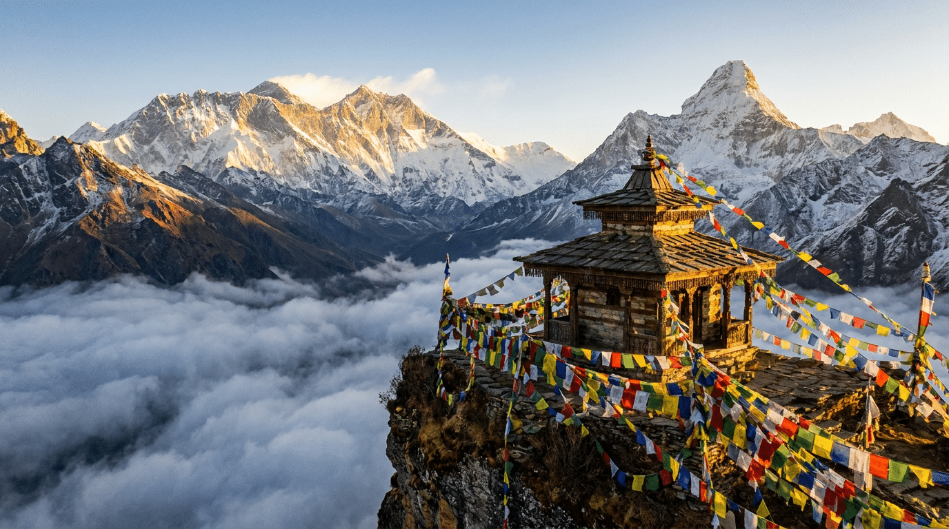
The Himalayas can look almost eternal.
From the plains of northern India, enormous walls of rock rise toward the sky. Snow-covered peaks appear fixed against the horizon, while rivers descend through valleys that seem to have existed forever. Across South Asia, these mountains are also places of pilgrimage, mythology and sacred geography.
Geology tells a very different story. The Himalayas are not a finished monument. They are an active geological system. The mountains are still being deformed by the collision of the Indian and Eurasian tectonic plates. Earthquakes continue to release accumulated strain, rivers constantly remove rock, glaciers reshape valleys and the climate interacts with the terrain at every scale.
The result is one of Earth’s most dramatic examples of a landscape that is simultaneously ancient and still being created.
How Did the Himalayas Form?
The modern Himalayas began to emerge from a much older geological story. India was once part of the southern supercontinent Gondwana and later moved northward as the Indian Plate separated from neighboring landmasses.
Between India and Eurasia lay the Tethys Ocean. As the Indian Plate moved north, oceanic crust was progressively consumed and the distance between the continental landmasses narrowed. Eventually, the continental margins collided.
That collision is the fundamental reason the Himalayas exist.
Continental crust is relatively buoyant compared with oceanic crust, so the Indian continent could not simply disappear beneath Eurasia in the same way an oceanic plate can sink into the mantle. Instead, enormous forces compressed and thickened the crust, producing folding, faulting and uplift.
A Collision That Has Not Stopped
The word “collision” can make the process sound like a single event that happened millions of years ago. In reality, the convergence continues.
Modern measurements using technologies such as GPS show that the Indian Plate continues to move northward relative to Eurasia. The crust across the Himalayan region accommodates that motion through deformation along major faults and thrust systems.
Some of the stored strain is released gradually through geological deformation. Some is released suddenly during earthquakes.
This is why the Himalayas remain tectonically active. The mountains are not simply the fossilized remains of an ancient collision. They are part of an ongoing continental-scale process.
Why Are the Mountains So High?
Mountain height is the result of a competition between uplift and erosion.
Tectonic forces push and thicken the crust, while rivers, glaciers, landslides, frost and chemical weathering continuously remove rock. Material eroded from the Himalayas is transported into surrounding basins and eventually contributes to enormous sediment deposits.
The landscape therefore operates as a dynamic system. Rock that rises in the mountains can eventually be broken down and carried toward the plains or ocean.
Some of the highest elevations are also associated with the broader Tibetan Plateau, which was itself strongly affected by crustal thickening during the India-Eurasia collision. The Himalayas cannot be understood in isolation from this larger tectonic system.
Mountains Made by Compression, Shaped by Water
Tectonics creates the basic architecture, but water is one of the great sculptors.
Rain and snow feed streams that cut valleys into rising terrain. Rivers transport enormous quantities of sediment, particularly during intense monsoon rainfall. Landslides can rapidly move material downslope, sometimes transforming valleys within hours.
Glaciers add another mechanism. Moving ice can grind and transport rock, leaving characteristic valleys, moraines and other landforms as they advance and retreat.
The Himalayas therefore represent an ongoing negotiation between forces that build elevation and forces that wear it down.
The Himalayas and the Monsoon
The mountains have a profound relationship with South Asia’s climate.
Moisture-laden air moving northward from the Indian Ocean encounters the rising terrain. Air is forced upward, cools and can release substantial precipitation. This orographic effect contributes to the intense rainfall experienced in parts of the southern Himalayan region.
The enormous elevation also helps separate climatic environments. The southern slopes can be relatively wet, while areas north of the main range, including parts of the Tibetan Plateau, are much drier.
This climatic contrast has influenced vegetation, agriculture, river systems and human settlement for thousands of years.
Are Himalayan Rivers Mainly Fed by Glaciers?
Glaciers are important sources of water in many high-altitude catchments, but the simplified idea that all major Himalayan rivers depend primarily on glacier melt is misleading.
Rainfall, seasonal snowmelt, groundwater and glacier melt can all contribute, with their relative importance varying by river basin, elevation and season.
This distinction matters because climate change does not affect every Himalayan watershed in exactly the same way. Changes in precipitation patterns, snow cover and glacier mass can alter water availability through different mechanisms and on different timescales.
Why Earthquakes Are Inevitable Here
The Himalayas are among the world’s major earthquake-prone regions because the tectonic forces responsible for building the mountains are still operating.
Where plates converge, rocks can deform and faults can become locked for periods of time. Stress accumulates until part of the fault system suddenly slips, releasing energy as an earthquake.
Large Himalayan earthquakes have repeatedly caused extensive damage to communities. Scientists therefore study active faults, historical earthquake records, geological evidence of prehistoric earthquakes and modern measurements of crustal motion.
Earthquake prediction in the sense of specifying exactly when and where a major earthquake will occur remains beyond current science. Risk assessment instead focuses on identifying active faults, estimating potential shaking and improving the resilience of buildings and infrastructure.
Glaciers and a Rapidly Changing High-Altitude World
Glaciers are among the most visible features of the high Himalayas, but they are not static reservoirs of frozen water.
They respond to temperature, snowfall, radiation, debris cover and other environmental conditions. Many glaciers in the wider Himalayan region have experienced substantial changes in mass and extent in recent decades, although rates differ considerably between individual glaciers and valleys.
Glacial change can affect downstream hydrology, ecosystems and hazards. One concern is the growth or instability of some glacial lakes, which can create the possibility of glacial lake outburst floods.
At the same time, the relationship between glacier retreat and river water is not simply “less ice means less water immediately.” Meltwater contributions vary through time, and individual basins respond differently.
A Biodiversity Hotspot Created by Elevation
The Himalayas are not just a mountain wall. Their enormous variation in elevation creates a succession of ecological environments.
Subtropical forests can occur at lower elevations, followed by temperate forests, coniferous zones, alpine meadows and high-altitude environments with sparse vegetation. Different slopes and valleys can also experience very different climates.
This environmental diversity supports a remarkable range of plants and animals, including species adapted to extreme cold, steep terrain and seasonal food availability.
The mountain system also functions as a biological barrier and corridor, influencing how species populations are distributed across Asia.
The Himalayas as a Source of Great Rivers
The mountains and surrounding highlands are closely associated with several major river systems of Asia. Snow, glaciers, rainfall and groundwater interact to supply watersheds that eventually flow toward densely populated lowlands.
This gives the Himalayas an importance far beyond their immediate geography. Water originating in or passing through the mountain system supports agriculture, ecosystems, industry and cities far downstream.
It also means environmental changes in high-altitude regions can have consequences hundreds of kilometres away.
Sacred Mountains Are Also Physical Landscapes
The scientific history of the Himalayas does not erase their religious significance.
Mountains and rivers across the region have long occupied important places in Hindu, Buddhist, Jain and other traditions. Particular peaks, lakes, caves and river sources became pilgrimage destinations, while stories and rituals gave physical landscapes layers of meaning.
Mount Kailash, for example, is revered in several religious traditions, while rivers such as the Ganga have profound sacred significance in Hindu practice.
Geology and sacred geography answer different questions. Geology asks how a mountain formed. Religious tradition asks what a mountain means to a community. A single landscape can contain both kinds of significance without one needing to eliminate the other.
Why the Himalayas Look Older Than They Are
Human perception works on a timescale of years and generations. Mountains operate on timescales of thousands, millions and tens of millions of years.
A cliff can appear unchanged for decades while a river removes tonnes of sediment. A fault can accumulate strain silently for centuries before an earthquake suddenly changes the landscape. A glacier can retreat gradually while leaving behind evidence of its former extent.
This creates an illusion of permanence. The Himalayas appear timeless precisely because most geological change is too slow to observe directly.
Could the Himalayas Ever Disappear?
On geological timescales, mountain ranges are temporary features.
If tectonic uplift eventually slows or stops, erosion can progressively reduce elevation. But the current Himalayan system remains tectonically active, so uplift and erosion continue to compete.
There is no meaningful human-timescale deadline for the “end” of the Himalayas. Geological processes operate far beyond the span of civilizations.
A Landscape of Constant Change
The Himalayas are therefore best understood as a process rather than an object.
The Indian Plate continues to converge with Eurasia. Crust is shortened and deformed. Earthquakes release accumulated strain. Rivers carve valleys. Glaciers reshape high-altitude terrain. Monsoon systems redistribute enormous quantities of water. Plants and animals adapt to the resulting gradients.
And human communities continue to give these landscapes cultural and spiritual meaning.
The Bigger Perspective
There is something almost paradoxical about the Himalayas. They are ancient enough to have shaped civilizations, yet geologically they are still young enough to be actively changing.
Stand beneath a Himalayan peak and it is easy to imagine that the mountain has always been there. Geology tells us that it has not. The rock was once part of another environment; the ocean once occupied the region between India and Eurasia; continents moved; seabeds became mountains; rivers began cutting new valleys.
The Himalayas are a reminder that what looks permanent can actually be dynamic. The mountains are not merely a monument left behind by Earth’s past. They are one of the places where Earth’s geological present is still being written.
The Himalayas Are Part of a Much Larger Collision Zone
The Himalayas are often pictured as a single mountain chain, but geologically they are part of a much wider zone of deformation extending from the northern Indian subcontinent into Tibet and beyond. The India–Eurasia collision did not simply push up one row of mountains. It shortened and thickened a huge volume of continental crust, producing faults, folds, high plateaus and deep sedimentary basins.
The boundary is also not a perfectly straight line. Different geological blocks respond differently to the continuing convergence. Some deformation is concentrated along major thrust systems, while some is distributed farther north into the Tibetan Plateau and adjacent regions.
This is one reason the Himalayas remain so important to geologists: they provide a natural laboratory for studying what happens when two large continental masses collide.
What Happened to the Tethys Ocean?
The rocks of the Himalayas contain clues to a time when the region looked radically different. Before the continental collision, the area between India and Eurasia included the Tethys Ocean. Sediments accumulated on its floor for millions of years.
As India moved northward, the oceanic part of the intervening region was progressively consumed. Eventually the Indian continental margin encountered Eurasian crust. Sedimentary rocks that had formed in marine environments were caught up in the collision and later uplifted to extraordinary elevations.
That is why marine fossils and other evidence of ancient ocean environments can occur in rocks now found high in the Himalayas and Tibetan region. A landscape that is today defined by snow and altitude once formed part of an entirely different world.
Why Earthquakes Are Part of the Same Story as Mountain Building
The earthquakes of the Himalayas are not an unrelated hazard sitting beside the mountains. They are one expression of the same tectonic process that built them.
As India continues to converge with Eurasia, rocks along major faults can become locked while deformation continues around them. Elastic strain accumulates until a fault segment slips. The resulting earthquake releases some of that stored energy, although the broader plate motion continues.
This creates a difficult problem for densely populated mountain and foothill regions. Earthquakes cannot currently be predicted with the precision needed to announce a particular event on a particular day. The practical scientific approach is therefore risk reduction: mapping faults, estimating likely shaking, enforcing appropriate building standards, improving infrastructure and preparing communities.
The Monsoon Does More Than Bring Rain
The relationship between the Himalayas and the South Asian monsoon is a two-way scientific story. The high terrain strongly affects atmospheric circulation and precipitation, while rainfall in turn helps shape the mountains through erosion and sediment transport.
When moist air is forced upward against mountain slopes, cooling can cause condensation and heavy precipitation. The resulting water enters rivers and groundwater systems and also accelerates physical and chemical weathering.
During intense rainfall, rivers can carry enormous sediment loads. Landslides can suddenly transfer large volumes of rock and soil into valleys, where rivers redistribute the material downstream. Over geological time, this erosion is powerful enough to remove material from a mountain range even while tectonic processes continue to raise and deform it.
The Landscape Is Also a Record of Climate
Glaciers, moraines, lake sediments, tree rings and other natural archives preserve clues about past environmental conditions. Researchers can use these records to reconstruct how temperature, precipitation, snow cover and glacier extent changed over time.
Such reconstructions are important because Himalayan climate is highly variable from valley to valley. Elevation, slope orientation, precipitation patterns and local geography all influence how an individual glacier or ecosystem responds to broader climate changes.
That variability is one reason sweeping statements such as “the Himalayas are melting” can hide important differences. The scientifically useful question is which glacier, which basin, which elevation and which timescale are being examined.
Why Himalayan Water Is a Continental-Scale Issue
The importance of Himalayan water extends far beyond the mountains themselves. River systems originating in or influenced by the Himalayas and Tibetan Plateau support populations across large parts of South and East Asia.
Water availability depends on a combination of monsoon rainfall, seasonal snow, glacier melt, groundwater and the storage characteristics of individual basins. Their relative contributions vary considerably.
This means climate change can create several different kinds of water risk. Changes in rainfall can alter floods and droughts. Changes in snow can shift the timing of runoff. Glacier loss can change the seasonal contribution of meltwater. Rapidly changing high-altitude lakes can increase certain flood hazards.
Understanding these systems requires basin-specific evidence rather than assuming that one hydrological pattern applies across the entire mountain range.
Why Biodiversity Changes So Quickly With Elevation
A journey from the foothills toward the highest peaks can cross several ecological worlds within a comparatively short horizontal distance. Temperature falls with elevation, growing seasons shorten and oxygen availability decreases. Rainfall can also change dramatically between exposed and sheltered slopes.
These gradients create opportunities for highly specialized plants and animals. Some species occupy narrow elevation ranges, while others migrate seasonally between different habitats.
The result is an ecological mosaic rather than one uniform “Himalayan ecosystem.” Human activity, changing land use and climate change can alter these relationships by shifting the boundaries between habitats.
Mountains Can Build and Destroy Landscapes at the Same Time
The Himalayas illustrate a geological paradox. The same tectonic forces that create enormous mountains also help generate conditions for their destruction.
Uplift raises rock toward the surface. Weathering weakens it. Rivers remove it. Glaciers grind it. Landslides move it rapidly. The resulting sediment is carried into the plains, where it contributes to some of the great alluvial landscapes of South Asia.
In that sense, the mountains and plains are parts of one connected system. The enormous sediment fans and river plains below the Himalayas are partly the downstream expression of processes taking place high in the mountains.
What Does “Young” Mean for a Mountain Range?
The Himalayas are commonly described as geologically young, but “young” does not mean recently created in a human sense. Their major uplift began tens of millions of years ago, and the landscape has gone through many stages since then.
At the same time, the present mountain-building process is still active. Peaks do not simply rise continuously like a growing building. Uplift, fault motion, erosion, landslides and other processes operate simultaneously, sometimes in opposite directions.
The modern Himalayas are therefore better understood as a constantly changing balance rather than a mountain range moving toward one predetermined final shape.
Sacred Geography Adds Another Layer
The Himalayas cannot be reduced to their geological history for the people and cultures that inhabit or revere them. Peaks, rivers, caves, lakes and passes have accumulated stories, pilgrimage traditions and ritual meanings over centuries.
For Hindus, Buddhists and other communities, particular landscapes may be sacred because of their association with deities, teachers, sacred narratives or practices. That significance is a cultural fact in its own right; it is not something geology can confirm or disprove.
At the same time, scientific explanations and sacred interpretations operate differently. A geologist can investigate the age and composition of a mountain. A religious tradition can explain what that mountain represents. The same physical landscape can legitimately be studied through both lenses without confusing their methods.
The Himalayas Are Not Just a Wall of Rock
Seen from a distance, the Himalayas can appear to be a simple barrier between the Indian subcontinent and the Tibetan Plateau. Up close, they are an interconnected system of rock deformation, rivers, glaciers, forests, weather patterns, ecosystems and human settlements.
Their influence extends from deep inside Earth’s crust to atmospheric circulation and from high-altitude glaciers to agricultural plains hundreds of kilometres away.
That scale is what makes the Himalayas scientifically extraordinary. They connect processes that humans normally study separately: plate tectonics, earthquakes, erosion, climate, hydrology and ecology.
The Deeper Perspective
The most remarkable fact about the Himalayas may be that their apparent permanence is an illusion created by the limits of human perception.
The mountains are old enough to contain rocks that record vanished oceans, yet active enough to generate earthquakes today. Rivers are cutting into terrain while tectonic forces continue to raise and deform it. Glaciers retreat and advance while climate patterns reshape the conditions under which they exist. Plants and animals shift across elevation gradients while human communities continue to attach cultural meaning to the landscape.
In other words, the Himalayas are not a monument left behind by Earth’s geological past.
They are an active experiment in how a planet builds, reshapes and eventually wears down its mountains—and one of the clearest places on Earth where the deep past and geological present can be seen in the same landscape.
Curiosity Publication by Aadvik Agastya
Sources & further reading
- U.S. Geological Survey — Earthquakes and plate tectonics
- Encyclopaedia Britannica — Himalayas
- Intergovernmental Panel on Climate Change — cryosphere and mountain climate research
Have a question about this topic?
Join fellow Qurons on the Quron Forum to ask questions, challenge ideas, share discoveries and explore further.
Discuss on Quron Forum