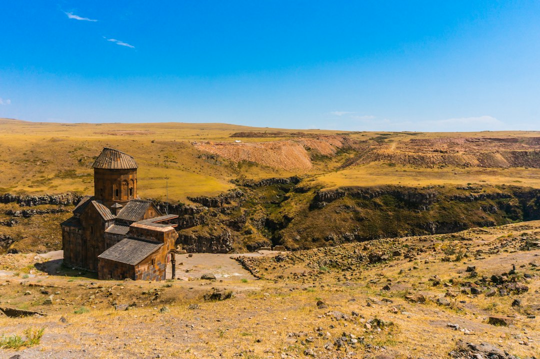
On a windswept plateau near the modern border between Turkey and Armenia stand the ruins of a city that once rivalled the great urban centres of the medieval Caucasus.
Its name was Ani.
Today, broken churches, defensive walls and empty streets occupy an open landscape. But around a thousand years ago, Ani was a wealthy capital, a centre of Armenian political power and an important node in regional trade.
Ani was once a capital
Ani became the capital of the Bagratid Armenian kingdom in the tenth century.
Its location was strategically important. The city stood near routes linking Anatolia, the Caucasus and regions farther east, allowing merchants and travelers to move through the surrounding landscape.
As its population and wealth grew, rulers and elites invested in walls, churches, palaces and public infrastructure.
The city of a thousand churches
Medieval writers and later travelers associated Ani with an extraordinary number of churches, giving rise to the famous phrase “city of a thousand and one churches.”
The exact number should not be treated as a literal census of a thousand surviving buildings.
What it communicates is the extraordinary density of religious architecture in a prosperous medieval city.
Several churches still survive in substantial form, demonstrating the sophistication of Armenian medieval architecture.
A city built for trade and power
Ani’s prosperity was not based on religion alone.
Its position connected commercial routes crossing the region. Merchants, craftspeople, administrators and religious communities contributed to an urban economy that supported monumental construction.
Archaeological remains indicate workshops, houses, streets and other features of a functioning city rather than a purely ceremonial capital.
The architecture is unusually distinctive
Ani’s churches display the characteristic stone architecture of medieval Armenia.
Domes, arches, carved stone surfaces and carefully proportioned interiors show a sophisticated building tradition.
The Cathedral of Ani is one of the most important surviving structures. Its architecture reflects developments in Armenian ecclesiastical design and demonstrates the technical ability of medieval builders to create large stone structures.
Fortifications protected the city
Ani stood on a plateau bordered by steep ravines, giving the city natural defensive advantages.
Massive walls strengthened those advantages.
Gateways controlled movement into the city, while towers and walls created layers of protection around the urban settlement.
The combination of natural terrain and engineered defenses helps explain why Ani could function as a major political centre.
Ani was part of a connected medieval world
It is easy to imagine medieval Armenia as isolated from the rest of Eurasia.
Ani shows the opposite.
Merchants and ideas moved across the region. Armenian rulers interacted with Byzantine, Persian, Arab, Georgian and later Seljuk powers.
Architecture and religious art also reveal cultural exchange. Cities on major routes rarely develop in complete isolation; they absorb techniques, artistic ideas and commercial practices from the wider world.
The Silk Road connection
Ani is often described as a Silk Road city.
That phrase is useful as long as it does not imply a single road running through one gate.
Medieval Eurasian trade consisted of overlapping routes that shifted according to politics, security, geography and demand.
Ani benefited from its position within this broader network rather than from one permanent “Silk Road” highway.
Religious diversity existed too
Ani was predominantly associated with Armenian Christianity, but its location placed it within a region where different religious traditions interacted.
Medieval cities could contain merchants and visitors from different cultural backgrounds even when political power was concentrated in one community.
This makes Ani valuable not only for Armenian history but for understanding the connected societies of medieval Eurasia.
Why did Ani decline?
Ani did not disappear because of one simple event.
Its fortunes changed as political control shifted across the region.
The Byzantine annexation of the Armenian kingdom in the eleventh century altered the city’s political position. Later, Seljuk expansion transformed the regional balance of power.
Earthquakes also damaged the city, including a major earthquake in 1319.
Trade routes shifted, political centres moved and the city’s economic importance declined.
The Mongol period and later changes
Like much of the Caucasus and Anatolia, Ani experienced further political transformations under Mongol and later regional powers.
The city did not simply vanish immediately after its Bagratid period.
Its population and importance changed over centuries, with buildings reused and new structures added.
This gradual transformation is important because “lost city” can make the decline sound like a single night of abandonment when the archaeological record is much more complicated.
Earthquakes left a deep mark
Ani lies in a seismically active region.
Earthquakes damaged buildings over the centuries, sometimes causing collapses that became visible in the ruins.
But earthquakes were only one factor in the city’s decline.
A city depends on political stability, trade, water, population and regional connections. When several of those systems weaken simultaneously, urban centres can contract even without a single catastrophic event.
Why the ruins look so empty
Modern visitors encounter vast open spaces where medieval streets and buildings once stood.
This creates the impression of a city suddenly abandoned.
In reality, the archaeological landscape is the result of centuries of depopulation, material removal, earthquake damage, weathering and the gradual loss of the institutions that maintained the city.
Stone was valuable. Buildings were reused. Roofs collapsed. Walls were quarried.
The empty landscape is therefore partly a product of time rather than evidence of a single disappearance.
Ani’s churches are only part of the story
The surviving religious buildings attract most visitors, but the city was also a place of homes, markets, workshops and administration.
Understanding those ordinary spaces is essential because a capital cannot survive on monuments alone.
It needs food supplies, craftsmen, merchants, officials, roads and systems of taxation and governance.
Ani’s ruins preserve traces of that larger urban ecosystem.
What happened to the people?
As Ani declined, people did not simply disappear.
Population shifted toward other settlements and political centres. Communities adapted to changing regional circumstances.
Migration is one of the least visible processes in archaeology because moving people often leave fewer traces than buildings.
The ruins therefore tell only part of the story of Ani’s end.
Rediscovering Ani
Modern archaeological work and architectural documentation have transformed understanding of the site.
Researchers have studied its churches, walls, inscriptions, streets and surrounding landscape to reconstruct the history of the medieval capital.
Preservation is challenging because the site is exposed to weather, seismic risk and the long-term effects of structural instability.
A city remembered across borders
Ani has a significance that extends beyond the modern political geography surrounding it.
Its architecture is central to Armenian cultural heritage, while its archaeological history reflects centuries of interaction among Armenian, Byzantine, Persian, Georgian, Islamic and Turkic powers.
That makes Ani a particularly powerful reminder that medieval identities existed within changing political landscapes.
The “lost city” is not really lost
Ani is often described as a lost city.
But the word can be misleading.
Its location is known. Its walls are visible. Its churches have been studied. Its inscriptions and archaeological remains continue to reveal information.
What has been lost is not the physical location of the city but much of the living world that once occupied it.
What Ani can teach us about cities
Ani’s story shows how urban prosperity depends on connections.
A city can become wealthy because it sits on important routes. But those routes can move. Political borders can change. Wars can disrupt trade. Earthquakes can damage infrastructure. Populations can migrate.
The same geographic position that creates opportunity can become less valuable when the wider political and economic system changes.
The medieval city the Silk Road left behind
Ani was not abandoned because its builders suddenly forgot how to live in cities.
Its decline emerged from a long sequence of political, economic, environmental and demographic changes.
What remains today are fragments of a much larger urban world: churches without congregations, walls without defenders, streets without merchants and houses without families.
But the emptiness is precisely what makes Ani powerful.
The ruins remind us that cities are not permanent objects. They are systems maintained by people, trade, institutions and geography.
When those connections change, even a powerful capital can become a quiet landscape.
The chronology matters more than the legend
Ani becomes easier to understand when its history is treated as a sequence rather than a single golden age followed by sudden abandonment.
The city rose to prominence under the Bagratid dynasty during a period when Armenian political authority was being reorganized after centuries of changing regional powers. King Ashot III made Ani his capital in the tenth century, and later rulers expanded the city and its monumental architecture.
This was a period of considerable political competition in the Caucasus. Byzantine power, Arab dynasties, Georgian kingdoms and later Turkic and Persian powers all influenced the region. Ani’s position gave it opportunities, but it also placed the city close to the fault lines of larger geopolitical changes.
What archaeology can actually tell us about Ani
The surviving landscape provides several different kinds of evidence. Buildings reveal construction techniques and religious institutions. Inscriptions can identify patrons, dates and communities. Streets, houses and workshops reveal patterns of ordinary urban life. Defensive walls show how rulers organized the city’s boundaries and controlled access.
These sources do not all answer the same questions. A surviving church can tell us much about architecture and patronage, but it cannot by itself tell us how many people lived nearby or how prosperous the entire population was. Archaeologists therefore reconstruct Ani by combining architectural, textual and environmental evidence rather than treating one spectacular monument as a complete picture of the city.
Trade was a network, not a single road
The Silk Road label can also obscure the geography of medieval commerce. Goods moving between eastern and western markets did not follow one fixed highway. Routes changed as rulers imposed taxes, wars disrupted corridors, merchants sought safer passages and demand shifted.
Ani’s importance came partly from being positioned within this changing network. Its merchants could participate in regional commerce, while its political status created demand for craftsmen, administrators and imported goods.
That helps explain why the city’s architecture was so ambitious. Monumental construction requires more than skilled masons. It requires agricultural surplus, taxation, organized labour, access to materials and institutions capable of maintaining large buildings.
Ani’s location was both an advantage and a vulnerability
The same geography that helped Ani become prosperous also exposed it to political instability. A city on a major regional corridor can benefit when trade is secure, but suffer when borders move or military campaigns redirect commerce.
This is one reason the decline of Ani should not be reduced to a single invasion or earthquake. Urban decline is often cumulative. A political centre loses importance, commercial traffic changes, maintenance becomes harder, buildings deteriorate, and population gradually relocates.
What happened after the Bagratid kingdom?
In 1045 the Byzantine Empire annexed the Bagratid kingdom of Ani. The city remained important, but the political framework that had supported its role as an Armenian royal capital had changed.
In the following decades, Seljuk expansion transformed the region. Ani changed hands again, and its history continued through several political periods rather than ending at the moment of the Byzantine annexation.
This distinction matters because the ruins contain layers belonging to different centuries. A medieval city is not a photograph frozen at the height of its power. It is an archaeological palimpsest in which buildings were altered, reused, damaged and sometimes abandoned at different times.
The earthquake was not the whole explanation
The earthquake of 1319 is frequently mentioned in accounts of Ani, and it caused serious damage. But an earthquake alone does not explain why a city remains empty centuries later.
By that period Ani had already experienced major political and economic changes. Earthquake damage could accelerate a process that was already underway, especially when a declining population had fewer resources to repair monumental structures.
This is a useful lesson in historical reasoning: a dramatic event is easy to remember, but long-term urban change is often produced by several interacting causes.
What remains invisible in the ruins
Monuments dominate photographs of Ani because stone churches and walls survive better than everyday objects made from wood, textiles or organic materials.
That creates a preservation bias. The surviving city can look more religious and monumental than the lived city actually was.
Behind the cathedral and defensive walls were kitchens, workshops, storage spaces, markets, animals, roads and homes. Most of that ordinary life has disappeared or survives only indirectly in archaeological traces.
The people of Ani were therefore more than the builders of its famous churches. They formed an urban economy whose survival depended on thousands of routine activities that rarely make it into popular histories.
Why Ani still matters
Ani is valuable precisely because it connects several scales of history. At the largest scale, it shows how political boundaries in medieval Eurasia repeatedly changed. At the urban scale, it shows how trade, government, religion and architecture reinforced one another. At the human scale, it raises the quieter question of what happens when a city loses the networks that once made it necessary.
The ruins are not evidence of a civilization that simply vanished. They are evidence of a city whose relationships with its surrounding world changed.
The real mystery of Ani is not where it went
There is no archaeological mystery about where Ani is. The mystery is how an urban system capable of supporting monumental architecture can gradually cease to function.
That question is relevant far beyond medieval Armenia. Cities rise because geography, institutions, population and commerce align. They decline when those relationships change.
Ani therefore offers a more interesting story than that of a “lost city.” It is a case study in how connected cities can prosper, adapt, fragment and eventually become ruins while the wider human world continues around them.
Curiosity Publication by Aadvik Agastya
Sources & further reading
- UNESCO World Heritage Centre — Archaeological Site of Ani
- UNESCO — Armenian Monastic Ensembles of Iran
- Encyclopaedia Britannica — Ani
Have a question about this topic?
Join fellow Qurons on the Quron Forum to ask questions, challenge ideas, share discoveries and explore further.
Discuss on Quron Forum